Access and route
Details
- Route
- Linear route, one way, desdending from North to South
- Municipalities
- Starting at the munitipality of Ardales and ends at the municipality of Álora
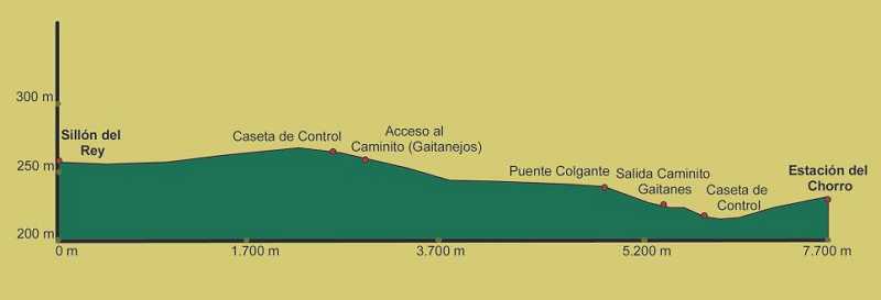
- Distance
- 8 kms
- Time spent
- 3-4 hours
Do not forget to visit the Visitors'´Reception Centre. We are waiting for you!
The route
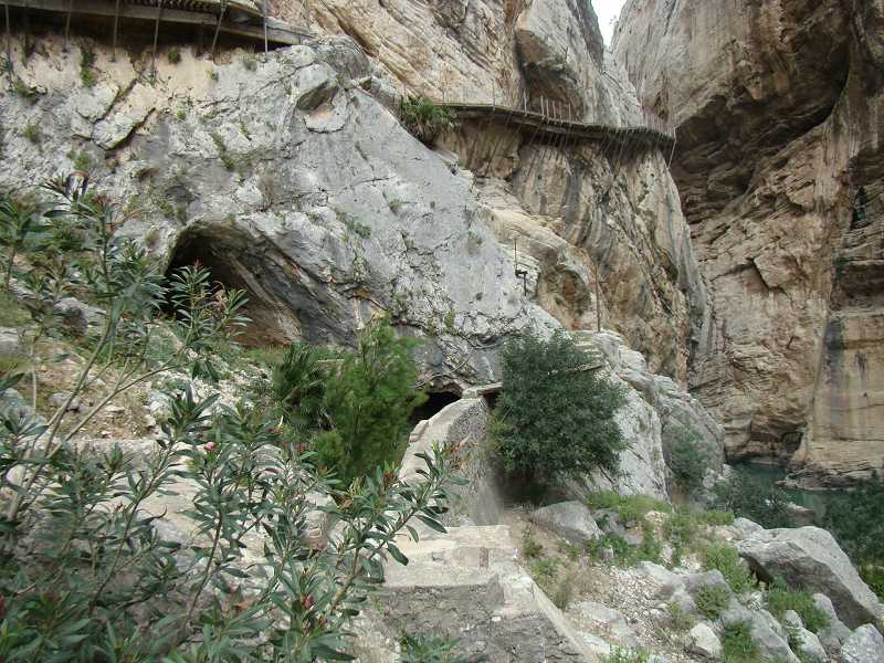
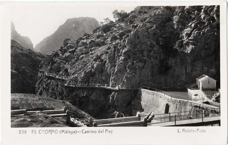
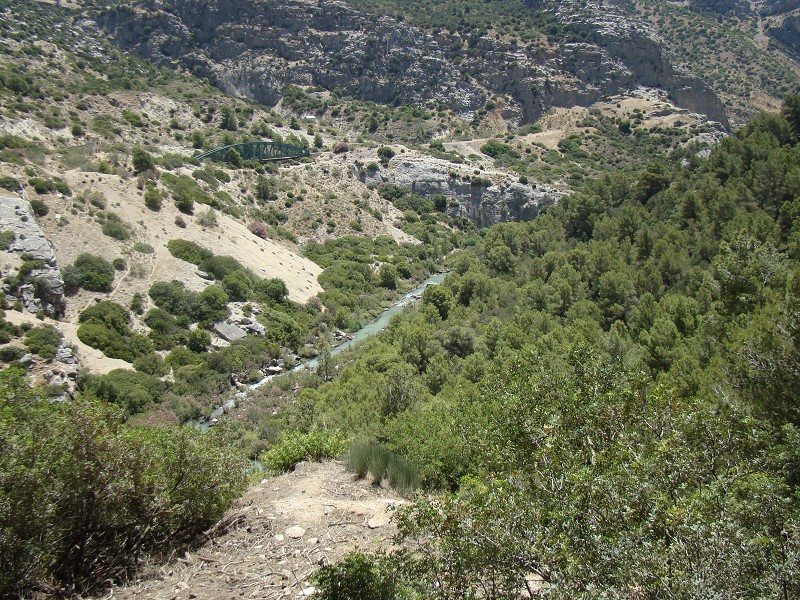
The route of El Caminito del Rey is spectacular, from its entry to the swamp of El Conde de Guadalhorce up to its exit via the El Chorro dam, given that we find ourselves in a unique natural setting that runs accross two gorges, cannons and a huge valley partly through trails and partly through boardwalks.
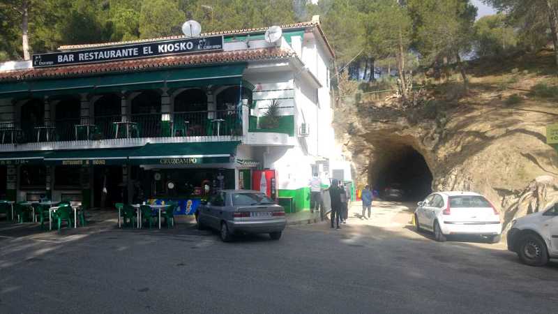
Access 1. Trail of Gaitanejo (2,7 km. route)
Entering through the 'Túnel Grande' next to El Kiosko restaurant, you will start the long route (2.7km) through a narrow forested trail with Aleppo pines planted to fix the floor and prevent the dam from clogging. At the exit you will find an Info signal "Caminito del Rey" spotting shortafter the old Gobantes Central, the first reversible kind in Spain and the great spillway for the Guadalteba dam ( 4 sections 11m long). Further ahead there is a meandre where the remains of traditional cave houses from El Gaitanejo "Casa de Farraya" still keep certain rooms (yards, furnaces, pantrys...). Later on, the trail descends up to river level (right shore) with riverside vegetation where you will be surprised by a great wall with a peculiar geological formation - tafoni - known as 'Gothic Arc' and an area with the info panel "Guadalhorce River in Gaitanejo section". The end is a few metres ahead at the Northern access Control Cabin, at the old electrical substation and Gaitanejo dam, the start of the Official Route.
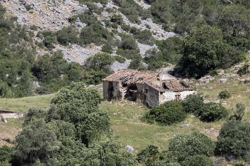
La de Casa de Farruya/Farraya, today abadoned and in ruins, benefits from sandstones´ fragility to excavate it as well as from the wall´s incline for its coating. Within its structures one can still spot its rooms and holes where the beams were nailed, the pantry, the furnace, etc. Some of these houses, distributed around the natural surrounding belong to medieval times and were ocupied by hydroelectric workers up to the 70s. The opening of El Caminito enabled the communication and provisioning to these houses with El Chorro, to the point where some of its residents ended up moving to the swamp's village.
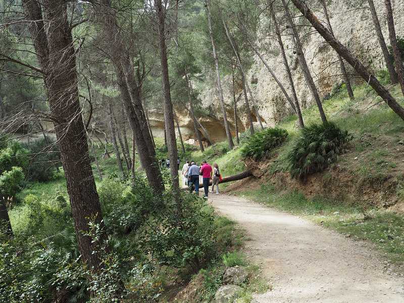
If you followed this trail you will have descended and walked part of the right side of the Guadalhorce river wherein a riverside vegetation grows, including reeds, canes, oleanders and tares with some poplars and willows. You will have also spotted certain birds related to fluvial channels, such as the cormorant, the grey heron or cetti's warbler. Dammed waters aided the development of fish populations, conditioned by the dam regulatory systems. It is common to find catfish, carps, crucian carps, black bass or bluegills amongst others.
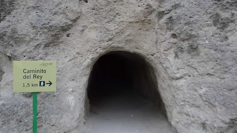
Access 2. Pedestrian tunnel and Gaitanejo´s track (1.5km. route)
The route from the 'Pedestrian Tunnel' situated 200m ahead of the restaurante El KIosko will allow you to shorten the walk (1.5km/25 min approx). This tunnel which is deeper (150m) and narrower than the previous one also gives access to a narrow trail that links to the Gaitanejo track which starts by a road diversion next to the restaurant El Mirador, which goes up until the viewpoint of Los Embalses and descends until the El Gaitanejo dam. The track, used for authorised and maintenance vehicles, will walk you down to a point where you can see dam's emmerald-coloured water. From a curve you will spot the circular silouhete of the 'Gothic Arc' or 'tafoni' with a different perspetive from the one at the Túnel Grande (river level). The Track continues until crossing the Tunnel and Tafonis Bridge, with its natural concavities, close to the dam of Gaitanejo and the Substation, where the Northern access Control Booth and the start of the Official Route is.
For the hiking lovers, visiting is recommended during the months of March and April when the flora can be best appreciated with its Aleppo pines, Juniper trees, Eucalyptus trees, willow trees or ash trees. The birds you will be able to spot are the black redstart, the peregrine falcon, the Bonelli's eagle or the vulture, because it is a vulture colony area, as well as the Kingfisher, the Cormoran, the Great egret or Grey heron which are related to the water environment. At sunset, it is frequent to spot certain mammals such as the Iberian ibex, the fox, the wild boar (more common at El Valle del Hoyo) and if you are lucky you will spot the Otter. Reptiles such as the lizard, the snake or the green lizard.
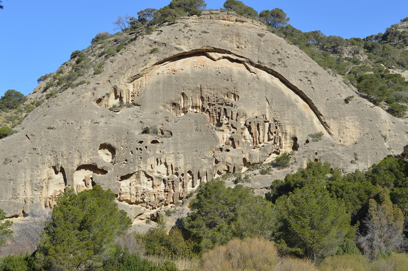
The geological milestone of the Gothic Arc
The wrongly named 'Gothic Arc' given that its circular shape does not correspond to that architectural style can be spotted on a sandstone wall in one of the most singular eroded formations of the area, formed by a natural slit or degradation. It is actually a 'tafoni' or alveolar formation generated when clay compressed within sandstone conglomerates by external processes (water and wind). Closely, an area has been prepared as a resting place with benches, tables and information pannels 'Guadalhorce river section in Gaitanejo' from where you can stop for a few minutes to spot numerous birds and listen to their chirping, even the first vultures nestle on the summits. Hence, you have descended surrounded by dense vegetation where the Aleppo pine is dominant as well as the Juniper tree, Eucalyptus, willows, ash trees and shrubs containing palmettos, thyme, bramble...until you reached the riverside's riparian vegetation.
Similar to the 'Gothic Arc' but not as spectacular you can find other 'tafonis' distributed by the Sierra Parda foothills and with the same erosive origin. What used to be Rupestrian houses (named 'Cuevas Pardas') can be seen nearby, benefiting from the hollows of 'tafonis' for their construction and inhabited from historical times by farmers and later on by workers until mid 20th century.
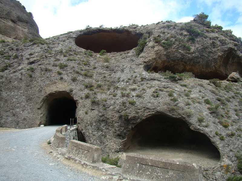
The tunnel and Tafonis' bridge.
For the construction as well as the upkeeping and provisioning of the hydroelectric infrastructure of El Gaitanejo (dam, central, cannal, boardwalks...) an access track had to be done including the tunnel and bridge in the surroundings of the El Gaitanejo dam which was built at the base of a small mogote perhaps benefiting from th cavities and natural hollows. Leaving the tunnel and from the curve right after the bridge turn around to watch the interesting ensemble of 'tafonis' where the exit tunnel was dug out. It is formed mainly by four huge hollows, two of which are regular and situated one on top of the other.
As you must know, the toponymy or name of the different places have a special interest and usually refers to the description of something related to the area. Hence, the name of 'Gaitanes Gorge, Gaitanejo or Tajos del Gaitan' refer to the name that used to receive the birds of prey that flew over this natural area, especially the bearded vultures. During spring and summer one can spot them flying through the narrow cannons and their nests.
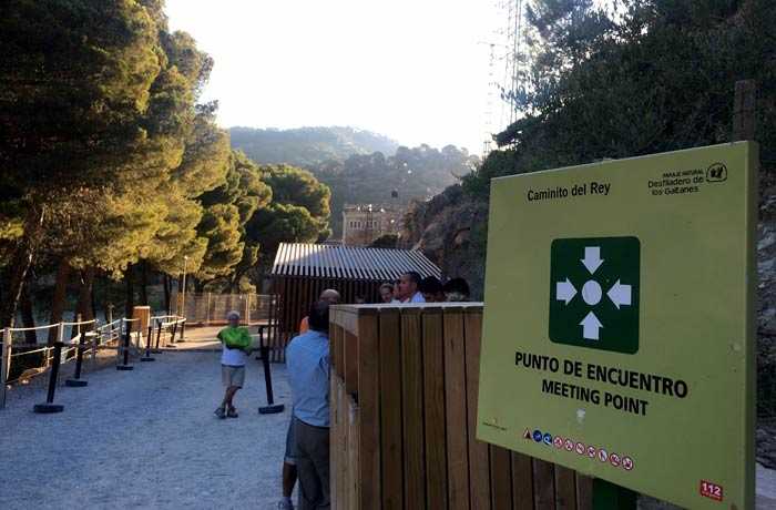
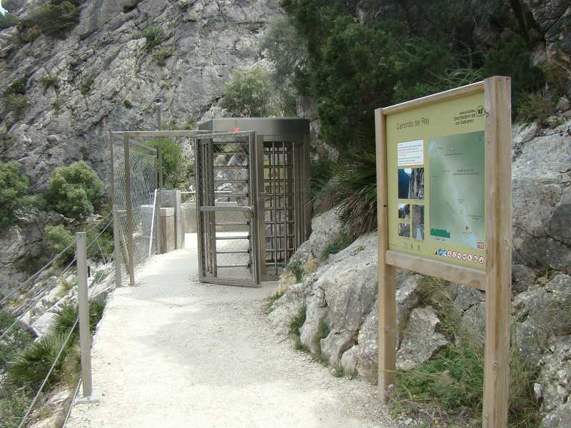
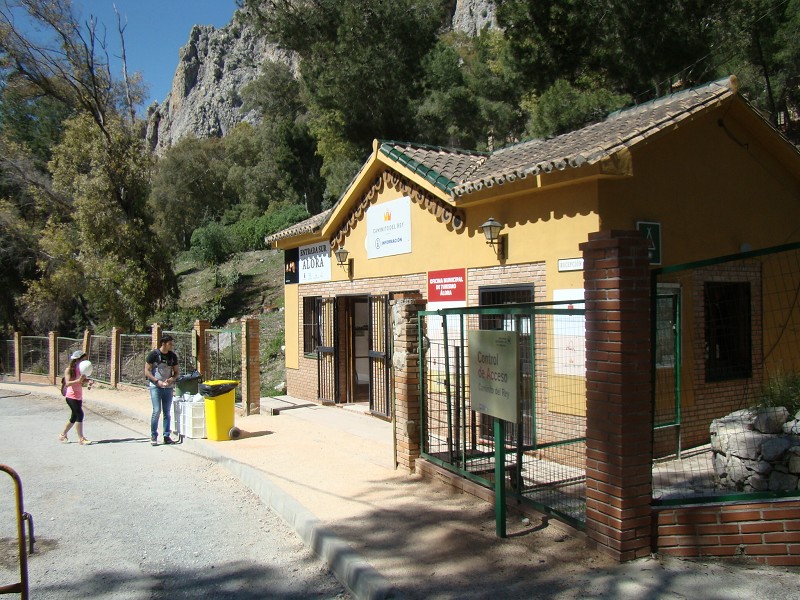
Visitors' reception booth and services.
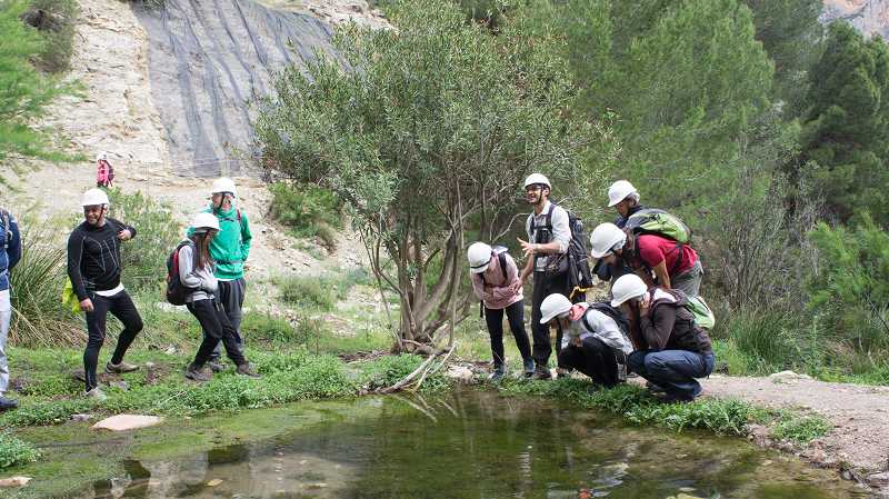
The trail and track, after crossing the aforementioned hallmarks, will take you to the Visitors' reception booth and its service area with information panels wherein two paths connect and the Official Route starts, half an hour or up to an hour walk from the start depending on the chosen path. At the Control Cabin visitors receive, after their acreditation, a protection helmet. Their footwear and non-authorised elements will be checked (umbrellas, hiking sticks, selfie sticks...) and they will be organised in groups depending on the timeslot. Guides will also give the introductory talk where they will insist on not throwing litter on the ground.
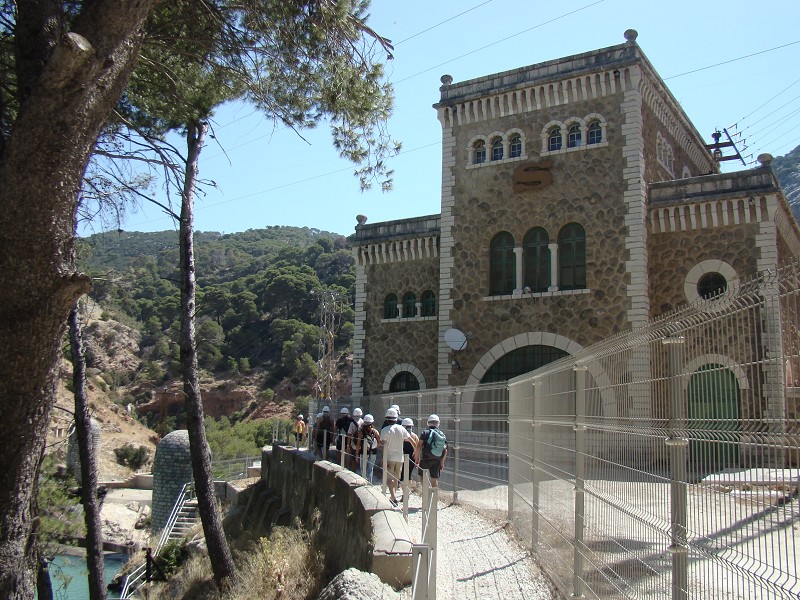
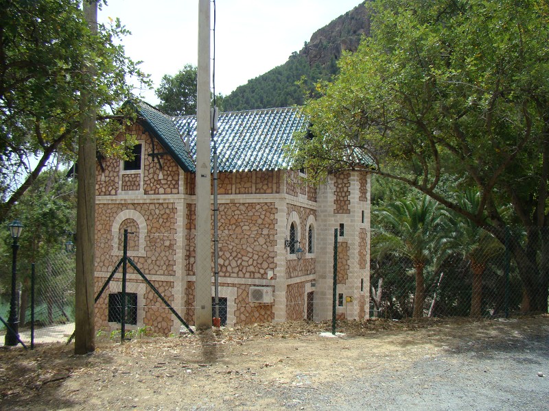
The Gaitanejo Hydroelectric Power station where the Reception Booth is set was one of the oldest in Spain, highlighting the Electric substation with a big 'S' at the front, memory of the Compañía Sevillana de Electricidad, former owner. The building has a rectangular shape (20 x 12, 50m) made of clear masonry stone pillars. The corners, edges and the crest are decorated with white limestone, metallic and green carpentry.
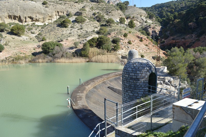
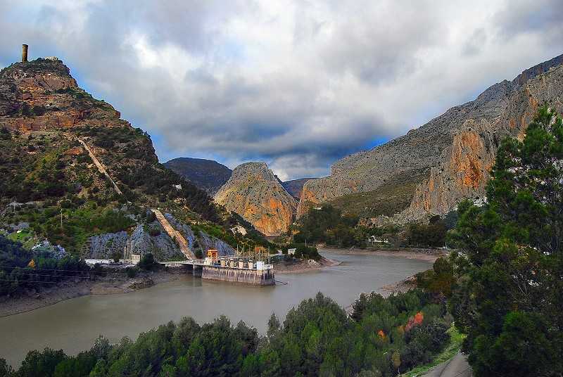
The Presa de Gaitanejo and The casas cuevas
Passing the old Electric Substation you will find a small circular area that surrounds a turret as a viewpoint. From its railings you will see the Presa de Gaitanejo (1927) planned by Rafael Benjumea to have a capacity of 4.600m3., height of 20m. and crest length of 55m. A gate and the regulation system funneled water along the Gaitanes Gorge until crossing the last cannon through a viaduct. The project was pioneer due to many reasons, but most of all for incorporating the Electric Power Station within with a great picture window 'cristalera de pavés' in the wall where one could see water cascade. It is not in use today and it mainly stores water that is piped until the Nuevo Chorro Station. It is also the spot to see the casas-cueva of Sierra Parda in front of the station, housing the staff who worked at the hydroelectric power station.
Troglodytic houses were made using the softness and hollowness of sandstone for their construction. There lived people dedicated to sherperding and agriculture, but also dam construction workers, workers of El Caminito or even those who worked upkeeping the Cannal and the Station. Some of their names are still known, such as the Sarteneja, the Paco de Encarnación, the Viñuela, the Teresita, the la Parda, the Frasco Reina, the las Conejas and at least three Sevillana houses. El Caminito meant a quick and comfortable access to all of them, to reach the village of El Chorro and the railway station.
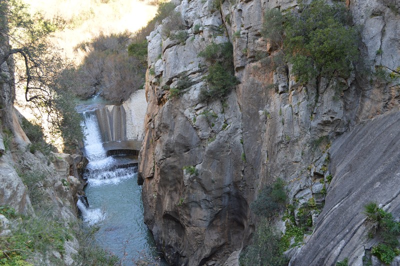
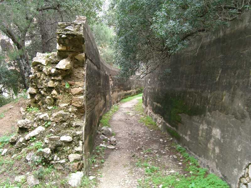
The Cambutas Dam, the start of the Cannal and the start of the boardwalks.
Leaving the viewpoint behind and after a slight descend through some steps you will enter a section having on the left side: the ravine, the leftovers of the small Cambutas dam and the main Cannal that starts here at a still visible Cannal pit. The traditional Salto del Chorro is located by the entrance of the Gaitanejo Gorge where the Electrical Power Station was set in 1904, being substituted by the New station of the Gaitanejo Dam. This first dam, partially destroyed during the 1921 flood and dynamited when it became obsolete was built at the river bed as a barrier or stone and concrete barrag. Next to it you can appreciate remains of stairs and old service boardwalks. The start of the Cannal (281m coat) is this Diversion Dam that intended to take advantage of the slope between the entrance of the Gaitanejo gorge and the exit at el Chorro until the Hydroelectric Power Station.
Do not stop looking, if possible with binoculars, the rocky wall ahead where commemorative plaques hang, marking the water level reached on different historical floods (08/02/1941 y 27/09/1949) caused by strong storms that periodically occurred in the area. One of the strongest one was the 1906 one which dragged so much material (trunks and branches) that it created an artificial barrage at the Gaitanejo ravine, causing the waters to find a way out through the tunnel, flooding the railway.
Upon entering the Boardwalks watch the floor boards from time to time, as they will have the number of metres walked engraved on them. At the beginning labels are placed every 50m until the Viewpoint of Rocas Llanas. the beginning of Valle del Hoyo is labled every 100m. After the valley once the second set of boardwalks has started, labels are again engraved every 50m until the exit through the southern gate with the very last 3200m label.
First cannon. Gorge of Gaitanejo
We start the first of the two great Gorges of the route, the Gaitanejo one, after a short route of ground trail. We are at a gorge not even 10m wide and the beginning of the first boardwalk.
Circular viewpoint, commemorative plaques and the first wooden boardwalk (0m. stage until the gate).
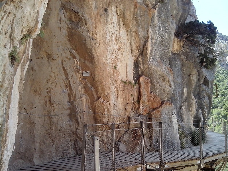
A few metres ahead there is an info pannel 'History of El Caminito del Rey', the turn that allows access to the first boarwalks and the entry to one of the two great Gorges or Cannons of the route. You will observe it is really narrow (not even 10m. wall to wall), tall and deep; It causes an impression upon starting the route and looking at the tall limestone walls and it will be the first great surprise to every visitor. The journey starts with a small circular viewpoint and a broadening where the commemorative labels are engraved and under the steep stairs that go down up to the river. Further ahead you will find the wooden Boardwalks, measuring 15cm wide and 5cm thick and cut to size to fit each particular place and with a 50m label that indicates the total metres walked. Overall 19.939m of wood have been used, 29.725 screws and 3,075 fittings or bolts, with the entire restoration work lasting less than a year.
Did you know there's an eror on the inauguration plaque? Watch the marble plaque that says 'The restoration of El Caminito del Rey was launched on March 26th 2015'...when it reality it was launched two days after, on March 28th. The reason is because there was a Germanwings aircraft accident wherein 150 passengers passed away, the counil decreed a three day mourning prohibiting public acts. As the plaque was already finished it was left that way. There is another plaque on top of this one, from 1921 that remembers engineer Rafael Benjumea and Burín, Count of Guadalhorce who put this project forward.
Current Boardwalks are the third ones made over time. The first ones were done to keep a quick access to the Cannal through the first Cannon. They were iron rods nailed to the rock holding thick boards wherein clamps were used to use a rope as a handrail. They were only used in this Cannon until the flood reached them, being replaced (1920) by higher ones 'Los Balconcillos' which used train riels (brackets and manual clamps) embeded on the walls, holding inlaid stones made of brick and cement. They were finished with a concrete deck, pilasters with rail tubes and tense arcs.
The Marmitas or Cambutas (50 m. routes)
The morphological aspect created by erosion is one of the most spectacular aspects of the Gorge or the Gaitanejo Cannon. This is shown through a group of small cavities, gullys and natural bowls 'Couldrons or Cambutas' that hang on the walls or are formed at the bottom of the Gorge due to the water and rocks erosion process which dissolve the limestone. These Cambutas are especially numerous and seen on the two first Cannons 'Gaitanejo and Tajo de las Palomas'. A privileged area to stop for a few moments is the point where the narrow Boardwalk broadens on a railed semicircle, creating a small viewpoint that will allow you to look down without any danger.
It is important to know that the river is the dividing line between the municipalities of Antequera (where the railway is) and Ardales (where the Caminito del Rey was built) along the Cannons and Gorges routes.
In this area it is easy to see what is left of the second Boardwalk built on cement and train riels. If you look up you will also see the rests of the old power lines between El Chorro and the Conde del Guadalhorce dam.
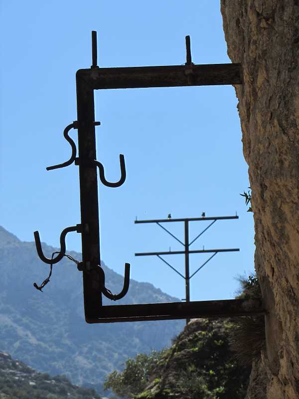
Remains from the old power lines (gourds) and revits (100m. route)
As you walk along the Boardwalk keep looking over your head, the iron anchors on the rocks 'U-shape' which were used for the old wiring to provide night lighting. Some still keep their isolation element 'crystal gourds' on the last boardwalks and some are even made of porcelain. You might have also noticed the iron anchors on the rocks 'revits' that belong to the old Boardwalk. They go up from the pilasters and curve themselves to nail to the wall. This type of anchoring that won't be seen again on the walk remind you of traditional long balconies from Málaga at the end of the 18th century. Some think that this type of clamping was Rafael Benjumea's idea, as he used to finish his projects giving a nod to delicate architectonic details.
At the end of this first Cannon, before entering the 'El Lugar de Soto' you can spot the remains of the first metallic structure used on the Cannal (iron beams, wooden planks and rope systems) which were replaced after the flood for the higher ones 'Los Balconcillos' that were later on named Camino del Rey following the monarch's visit. This second structure was made of steel, brick and cement. Cement was also used on the downhill that connects the two first sections of the Boardwalks during the restoration process.
El Soto
Between the two cannons, the Gaitanejo and the Tajo de las Palomas ones there is an opening known as Lugar del Soto which is really interesting from many points of view.
Start of El Soto: Known as 'Butter Stairs' and the Neolithic Cave of El Soto (300m. route)
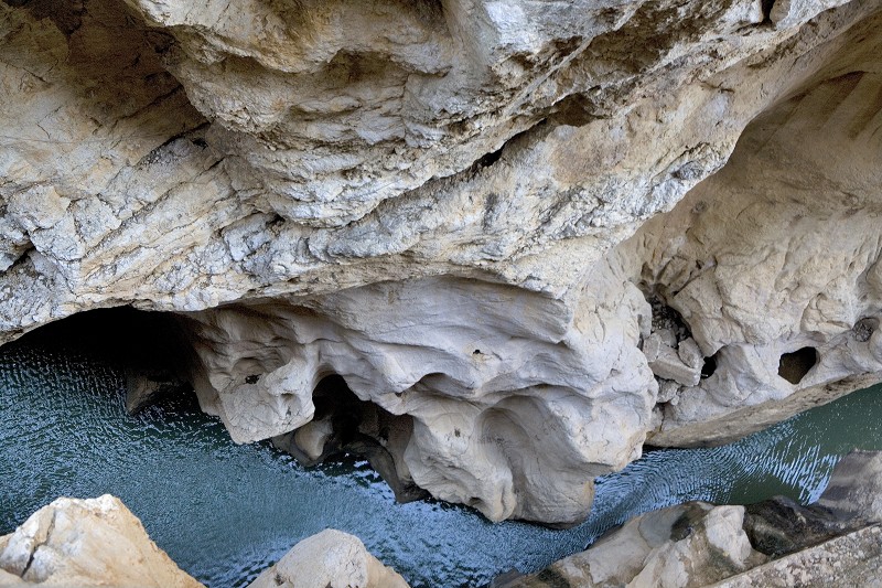
The first Cannon's exit is found walking down a steep hill that changes direction through narrow the narrow curves of a cement boardwalk and the 'Butter Stairs' named after its wave form, which has been kept for the restoration. On this downhill walk and looking at the railway (1865) you reach the river's rectangular viewpoint. You have entered the place known as 'El Soto', a small pond between the first and the second Cannon. From there and looking back to the left there is a triangular Cavity that goes unnoticed but that contains remains of neolithic period habitat (5000. B.C). This area was used by mountain goat hunters that fished salmon to complete their diet, based on grains and beans.
Leaving the Gaitanejo gorge, the area opens up so if you look up you will most likely see one or more vultures flying above. Remember this place was shut for decades, becoming a sanctuary for its flora and wildlife.
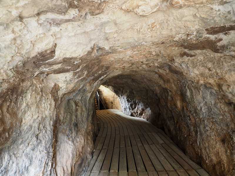
The small tunnel/underpass that crosses the Cannal (350m. route)
Looking at the big Railway Slope, the wooden Boardwalk continues to use the exterior wall of the Cannal until reaching a limestone massif drilled by a small underground Tunnel. The Boardwalk also goes across this area from the Tunnel and over the Cannal, on a two-level route with some steps (up and down). There are two alternatives, you can go around the rocky area through the old boardwalk whereby you can spot the group of Tafonis at the end of 'El Paso'
Fron 'El Soto' a good portion of the Cannal is on open air at first and then goes underground. There, you can see how building this water piping system took a lot of effort at the time because it is dug on limetstone rocks. Nevertheless, you can spot different elements of the Cannal such as an iron gate with its stopcock .
Second Cannon. El Tajo de las Palomas
Following a long curve wherein the boardwalk goes arunds a rocky wall you start leaving El Soto and delving into the second Cannon, known as el Tajo de las Palomas.
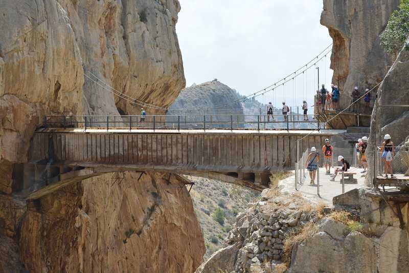
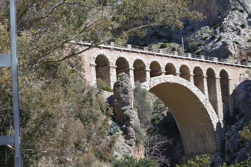
Puente del Rey (700 m. route)
El Puente del Rey, named because the monarch Alfonso the 13th crossed it (21.05.1921) after stepping down from the train was known beforehand as the 'del Tajo de las Palomas, de la Cueva del Toro, de la Fuente del Toro or Tensado'. The aim of having this little 'Puentecito' on the open space between the two tunnels was to communicate the hillsides of El Tajo river, the railway and the service boardwalks that aided the loading, unloading and transport of materials and members of staff. From this spot you can see a few tunnels that were built by work forces. Each one of them used dynamite to drill into the mountain until reaching the centre even though many times the size or light in the tunnel was not even or smooth. You can also appreciate from the end of the Bridge the cement resting benches from the railway siding.
The passage to save both sides of el Tajo de las Palomas was built as a thin boardwalk 'postensada' through cables that held the concrete deck (that is why it is called Puente Tensado). The structure ended with small stairs, a low wall, a security handrail and two concrete benches. From the Bridge's viewpoint to the right you can see the 7th tunnel 'Rocas Llanas' from the Córdoba-Málaga railway that is 325m long. At the end of it, a small viaduct was built to save the cliff Cañada del Lobo.
La Cañada del Lobo is a highlighted landmark of the area that goes from the Sierra de Huma's peak (1191 m) falling precipitously as there is a 1000m slope until reaching the Tajo de las Palomas. It is named after the Wolf, animal that inhabited the area and whose last animal was hunt in 1941.
Desander. Cueva del Toro (705 m. route)
It can be considered that the first section of the Canal ends at the Cueva del Toro, following a 1400m route. The first great Desander is established in this area, in front of the Bridge with a raft built with retaining walls and by the guard's house which is now gone. A desander is a structure to hold sand and other sediments that are brought to surface by the Cannal, preventing them from entering the next section of the Cannal and to the Hydroelectric Power Station. Therefore, desander was a crucial task. The wide structure was shut with gates and allowed soil's disposal through sewers that went straight to the Cannon. Workmen would work over the wall with their poles and it was a risky procedure although there are no reports of any accidents happening.
Over the Desander there is the Cueva del Toro, which names this space. It is one of the many caves in this karstic landscape and it was used in different periods of time, especially by blacksmiths and as a forge while work was being done in the area. It is important to highlight that, during the neolithic period it was used as a cave-shelter.
You will find a resting bench as you will have done a good part of the route and you will be able to see the Bridge King Alfonso the 13th crossed in 1921 as well as vultures flying above. This is the place where guided groups will stop and listen to the guide's explanation of the different elements of interest: The Bridge, the railway, the Desander remains and the Cannal that is hidden underground.
Rocas Llanas Viewpoint (900 m. route)
Leaving the Desander behind and after walking down a sinuous stretch of the Boardwalk you will reach the projection of a rock through which you access a ladder and a landing 'Rocas Llanas Viewpoint' with an informative pannel about the area's wildlife and the 900m plaque. This is a meeting point where groups can take spectacular panoramic pictures, as you can also observe the peculiar rock formation ahead and the enormous wall of Tajo de Ballesteros a rocky escarpment tainted orange due to the iron oxide that contrasts with the black and white stains of the limestone. To the left you can spot the railway's quarry. At the back, part of Valle del Hoyo and to the right and all above, los Tajos de Almorchón (663m) that belong to Sierra de la Pizarra. At the back you can also spot el Peñón del Cristo or Castillón de la Ermita (619m) which usually attracts many hikers.
The final section of the second Cannon ends with great ravines as it opens up. Along the Valle del Hoyo, the impressive Tajo del Ballesteros will always be present with numerous caves that contain the nests of an important vulture colony. Look up to see their majestic flight as it's rare not to see them taking advantage of the air's upward currents.
This is the area where you will start to understand the effort it took to build the Málaga-Cordoba railway line in 1865, an unprecedented milestone that was built in less than six years. The terrain was uneven, forcing a great engineering work especially around El Chorro, with many tunnels, viaducts and bridges. The 192km were finished in 1866 with 17 tunnels, 8 viaducts and 19bridges from which a great part were built on the Gaitanes' Gorge and its really uneven terrain.
El Valle del Hoyo
The river water, after great ravines and rapids that make a lot of noise gets calmer and enters a natural space with lush vegetation. We are at El Valle del Hoyo.
Rest Area and Informative Panels (910m route)
The river water, after great ravines and rapids that make a lot of noise gets calmer and enters a natural space with lush vegetation. This is the start of El Valle del Hoyo, which opens up in a different scenery until you can distinguish the last Cannon 'El Gran Gaitán'. So, on solid ground you will leave the Viewpoint and the railway going into the Valley by the Cannalon a 1800m route. Along the trail you will encounter different piping elements (bridges, gates, slopes, desanders...), highlighting natural landmarks (the Sapito Pintojo pond, wild pine forests, bat caves...) as well as resting areas and informative panels. The starts off at the bottom of the Tajos de Almorchón and in front of Tajo de Ballesteros with its interesting vulture habitats and depending on the hour you will be able to spot them flying around.
Hence, the central area of the Gaitanes' Gorge is a circle of mountains enclsing the Tajos de Almorchón to the right (Ardales) and the Antequera hillsides through which the railway runs through with three rocky formations (Tajos de Ballesteros, Tajo de los Estudiants and la Huma. This latter one with 1191m high). All this shaped a closed Valley that keeps surprising visitors due to how green its pine tree forests are and the emmerald river water.
Resting area by the openin of the Cannal (1200m route)
Going down a sandy footpath you will reach a narrow curve opening again to the Cannal for 4 metres protected by cables. The trail continues down a sinuous path, looking at the river's meander and the Peñón de Cristo and reaching a wider opening of the Cannal which is also protected by cables. You will reach a cabin and 1200m beacon. Here, in an area limited by pines there is a resing area with a bench and an informative panel about the 'Flora' wherein you can stop and observe the Valle del Hoyo panoramic view with the Tajo de Ballesteros to the right and the Tajo del Estudiante with its quarry at the bottom. After this, the narrow trail is followed by a long and sharp drop, protected by security cables until reaching a a grid that prevents the slope's deterioration and where a wall of roots and flora has grown. Ahead, you will reach a second landmark.
Many of the plants you will see along the way are protected and some are at risk of extinction due to their uniqueness such as the African Rucapinos, Sarcocapnos baetica, Muchas de las plantas que se ven a lo largo del recorrido están protegidas y, algunas, en peligro de extinción por su extremada singularidad, caso de la Rucapinos africana, Sarcocapinos baetica, Campanula mollis, Chaenorhinum rubiflolium or Cytissus moleroi.
Sapito Pintojo Pond (1380 m. route)
You have reached a shaded turn with ruined structures of the water Cannal (walls, gates...) that were part of another Desander from which a small stream created the 'Sapito Pintojo Pond'. This habitat was prepared in 2015 to be a natural space where the small amphibian and endemic species of the area could develop, laying eggs and reproducing the same way another area at the end of the valley was prepared for bats, actions that try to improve native flora and wildlife. Hence, it is one of the few open spaces of Valle del Hoyo with tall carob trees and two set of benches where you can rest.
At this point you can rest for a few minutes, get hydrated and have some food if you have brought any. There is still a long way ahead so a few minutes, especially if there is any shade, will be comforting. The tall carob trees are part of the medieval vegetation that was planted by the Berber tribes to help shepherding.
Valle del Hoyo Desander (1510 m. route)
Leaving behind the lowest part of the trail of Valle del Hoyo 'Sapito Pintojo pond' you continue up a trail wedged within the pine forest where the Cannal's quarry walls level up with the terrain and reach the 1400 and 1500m beacons. Another important element was based here, a Desander with a great water raft that helped the desanding. Here you can watch the spinder through which the wheel activated the water gate. There is another resting area here even though the area is covered by the grove and big rocks that have fallen with time. It is cosy and allows you to spot the Tajo de Ballesteros and Tajo del Estudiante ahead'.
Great Rock Collapse (1800 m. route)
Leaving the raft, the Cannal continues over a small bridge 'puentecito'. Simultaneously, the trail gains height between bushes and great rocks until a space that holds a 'hollow carob tree', liked by photographers. The area, with old marks on rocks 'MP5' and 'MP6' is distinguished by a 'crag' with a turret and remains of an old house (1600m beacon). The trail continues up until reaching a breakthrough on the Cannal and further up, reaching a clear where a 'rockfall' made a true natural viewpoint. You are in the middle of the Valley, surrounded by tall gorges that give you a great perspective of the valley. You can also spot the railway with its unique metal bridge formed by two green arcs that give access to the tunnel. Finally, notice the white sheds where dynamite was kept 'el polvorín' and further away, the tall hills of Antequera.
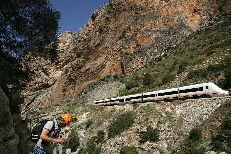
In the heights and at the back you can spot groups of vultures flying near el Tajo de Almorchón, where the viewpoint of vultures is found. The peaceful landscape can be altered by an incoming train, either local or a cargo one, either going up to Bobadilla or down to Málaga. Be reminded that this railway is not the AVE one (high speed train) that runs mainly underground in a 7km long tunnel at the municipal district of Valle de Abdalajís until leaving through the viaducts of Álora.
Casa del Hoyo (2100 m. route)
After the rockfall and another hollow carob tree, the trail keeps going up looking at the Peñón del Cristo, passing by slopes, branch arches and canopies reaching a curved marked by a small milestone 'MP' and a rangy dried pine trunk (1200m beacon). Here you can spot the Casa del Hoyo ruins to your left, built in the middle of the valley a few metres away from the river with the railway tunnels at the back. The house is named after the leafy forest, also named after its Orange trees. Abandoned, the house is witness of the way of life in a different time where it was a small agricultural explotation. Taking its water from the Cannal, its pond supplied both the family and the orange trees garden, other fruit trees and the herd.The house was built before the old boardwalk, as there are registers from the people who inhabited the house dating to the end of the 19th century, descendants from Álora and Ardales.
There was a subsistence economy in the household, consisting of a few cows, chickens, pigs, goats and sheep to make cheese. At the end of the 70s the house was abandoned and became a shelter for mountaneers and rock climbers who accessed the gorge walls. During the 80s archaeological sounding detected the presence of spanish and islamic medieval ceramics, indicating the existence of a settlement at least from the 13th century, probably a small farmstead or labour house القرية / al-qarīaor.
Breaking of Tall Walls. Cannal (2400 m. route)
Leaving the apex of the small Fault and due to the change of direction, the boardwalk continues with the completed route and viaduct to the left until the curve looking at the cannal bridge. Here is where the boardwalk ends at a concrete space where the zip-line anchoring used to bring materials from the railway was situated. This area that also included the Cannal guard's cabin now holds a wooden bench where visitors can wait their turn to cross the Bridgeas well as the commemorative plaques of the zip-line's accident. The old aqueduct bridge or Eugenio Ribera Viaduct was built in 1904as a complex work of engineer to transfer water between the two gorge walls. Just before going up the stairs and to the right the underground Cannal exit is situated, from a great rock cavity restored in 2017 as an alternative interior exit.
The aqueduct bridge for water transfer (35m) between the two vertical walls (300m) was crafted by the engineer Jose Eugenio Ribera Dutaste, ordered by the engineers Leopoldo Wener and Rafael Benjumea. They used a risky technique using guy cables that held the boards which turned into a wooden base. Work on the gorge was done by workmen, some of which marines, hanging on the abyss 105m above the river.
The Aqueduct Bridge of Ribera or the Cannal Viaduct, which cost 30.000 1904 pesetas was also used by visitors of El Caminito del Rey. Nowadays it can be used to transfer water from one side to the other but it is fitted in with tubes.
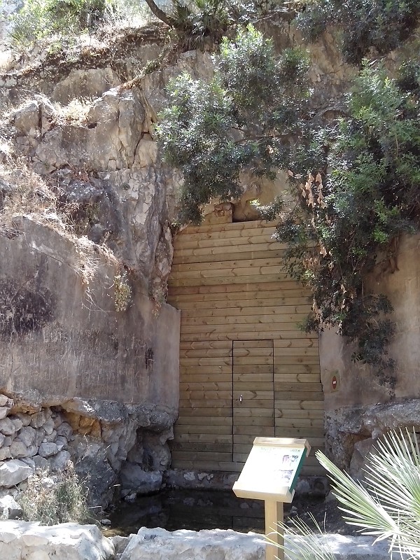
Bat shelter (2390 m. route)
In the resting area, an old service tunnel has been restored into a Bat Shelter, aiding their hibernation. The end of the cave, surrounded by vegetation with a water sump in its base has been closed with a big wooden gate that has a small window on top giving entrance to these 'chiropteras', only mammals able to fly. As the 'Bat shelter' informative panel indicates, you can find threatened species here such as the Rhinolophus, the long-fingered bat or the common bent-wing bat. Hence, their particular biology requires the existence of safe shelters wherein to spend the day, reproduce and spend their long hybernation period which is around 183 days.
The bat is an extremely threatened animal, having been paradoxically considered harmful even though they are great allies to humans because they feed on many harmful insects such as moths, mosquitoes etc. They play an important ecological part as pollinators, controlling insect and small vertebrae's plagues and having an important seed dispersal role.
Cannal Gate (2390 m. route)
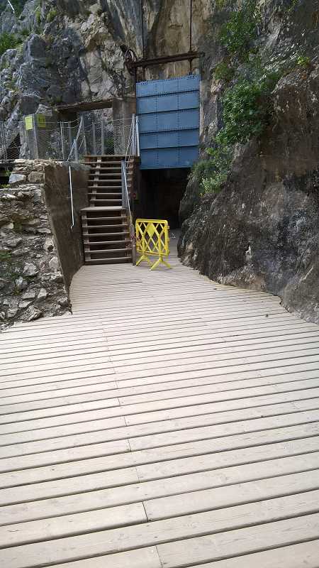
From the resting area and the Shelter, the trail continues through a snorter section of the Cannal (2400m beacon) which sticks to the walls of Peñón del Cristo (rockfall information panel) which will finally lead you to small wooden steps to access the last section of the Boardwalk. Stop for a few seconds for the panoramic view of Valle del Hoyo Here, the Cannal would split and go into the rocky wall in which visitors can cover 300m that have been restored and have lighting. The small steps is lifted over the structure of a 'Cannal Control Gate' that has an up and down machanism. Its different elements are: board or chopper knife, a spindle, frames wheel and access ladder.
Here, the cannal starts a practically underground route with a small opening at the apex of a Small Fault up to the aqueduct bridge. In 2017 the Cannal was reopened following its restoration, allowing transit through its interior and as an alternative to the air trail the days in which due to rain or wind, rockfalls happen. A practical solution to avoid closing the Caminito or forcing visitors to retrace their steps.
There are small hollows on the tunnel's ceiling due to bore-holes which are used as daytime shelter by different bat species. To avoid disturbing them, small led lighting has been placed at low height.
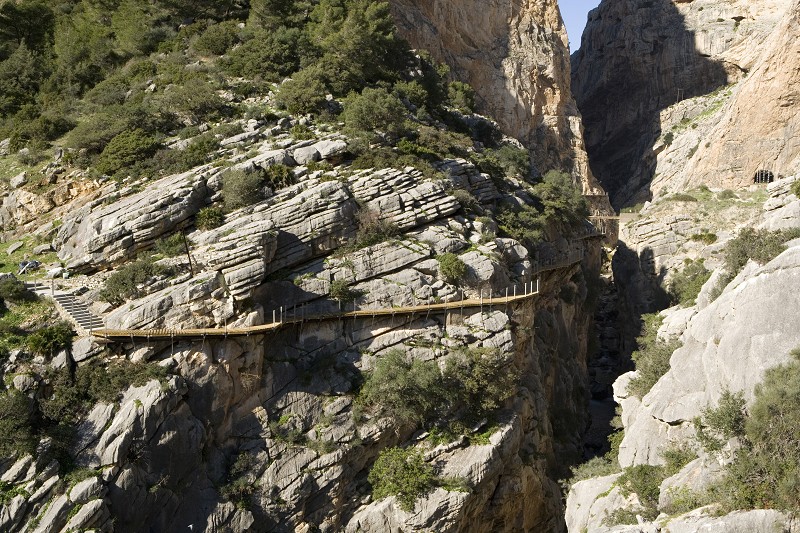
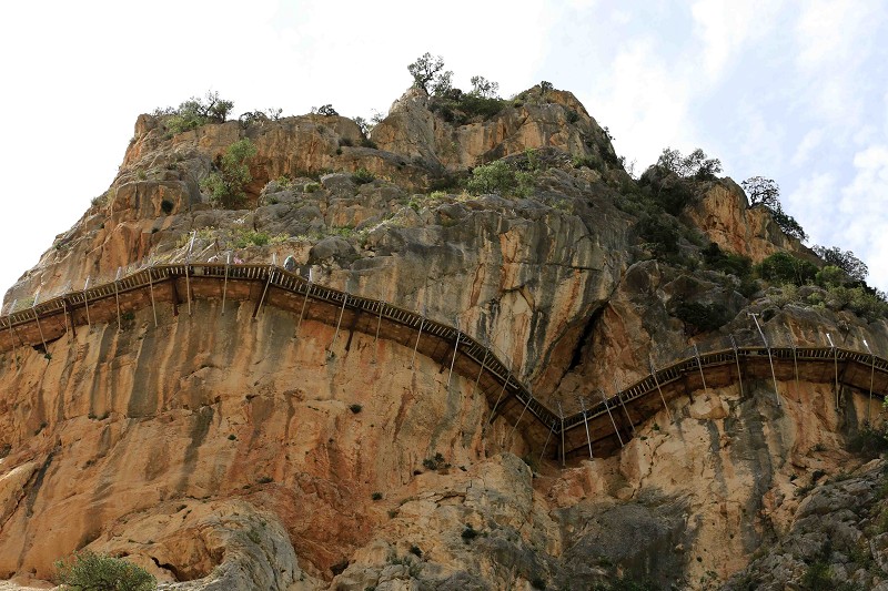
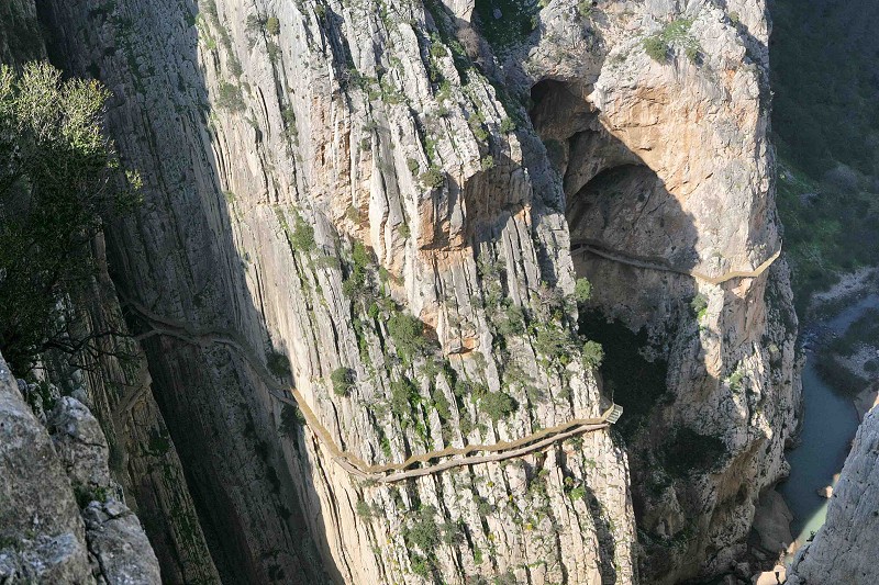
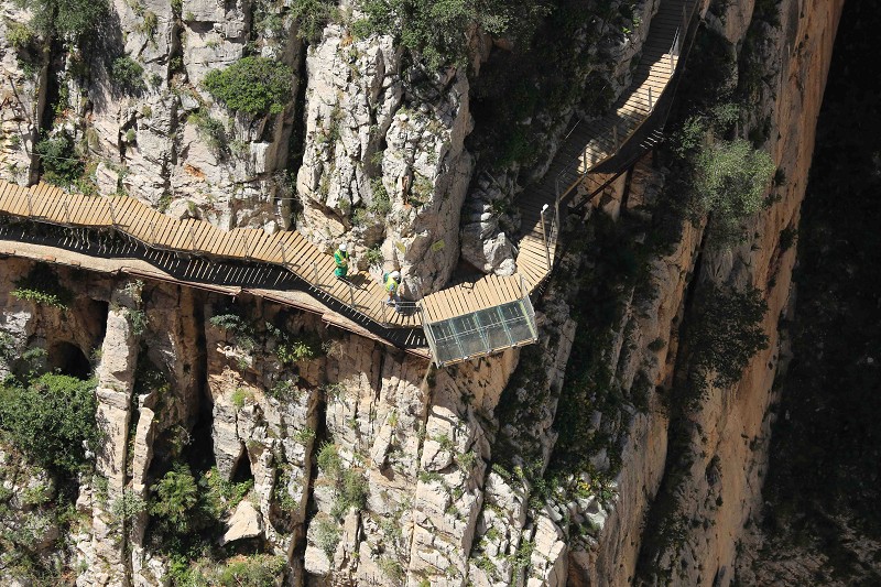
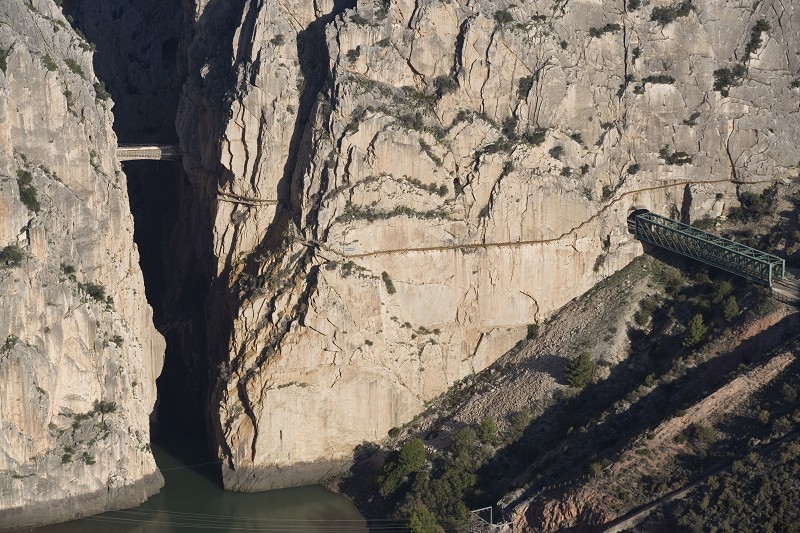
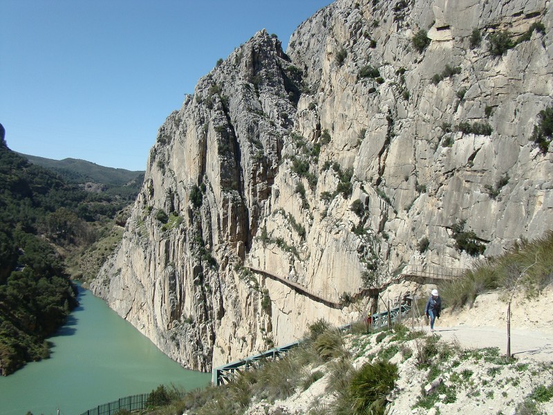
Third cannon. Gaitanes' Gorge and South wall
Access to a third cannon is done by a hanging set of boardwalks over 100 metres high. This is the most overwhelming part of the route. The last section of El Caminito is done through some stairs and a hanging boardwalk that are placed above the original boardwalk of the southern wall. Looking down you will see the new Hydroelectric Power Station of El Chorro.
Stat of the second boardwalk (2500 m. route)
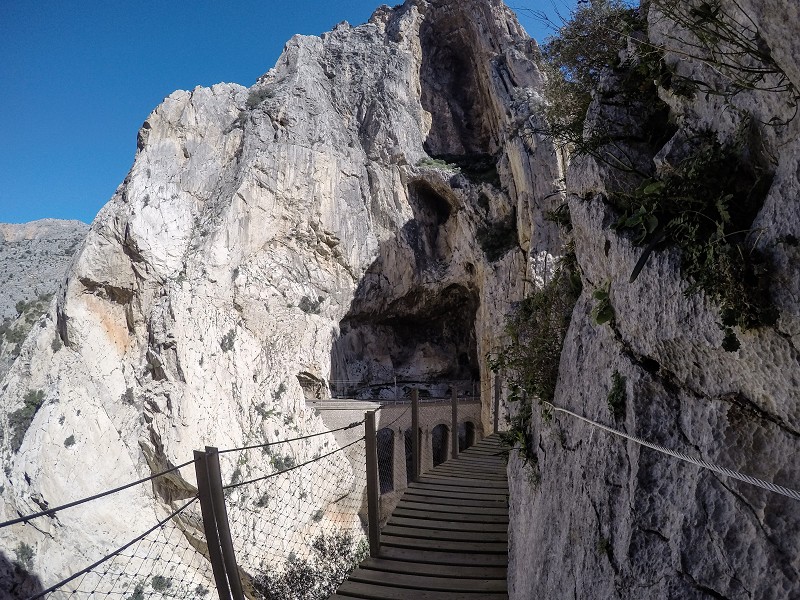
Acces to the third cannon is done through a hanging section of the boardwalks that winds through the overhanging walls in a narrower route that borders the Gaitanes' gorge, including the Falla Chica with its shut apex. The access is 800m long with 250m tall walls and more than 100m above the river until the Acueduct and the Hanging Biridge. Some sections are found 1m above the old boardwalks, reaching a curve underneath the Peñón del Cristo and the bend 'Recodo' which includes many cavities. Accompanied by the security cable 'cable de la vida' you will be surpried by two limestone columns that signal the entrance to the gorge 'El tajo de las Tres Cruces con los Nichos de San Cristobal' to the left and the 'Peñón del Cristo o Castillón de la Ermita' to the right.
This last Cannon is the best one to observe the mountain stratum's verticality. If you look up from the river up to the railway and on to the summits it is more than 250m. The route along the new boardwalks allows you to watch the old boards with a sense of unease, the deteriorated Caminito del Rey more than a century after it was first built. This route will make you feel like coming onto the river and back into the mountain in different occasions due to the transverse faults opened due to erosion.
Centenary Juniperus Sabina (2550 m. route)
100m after the boarwalks start and after walking under the crystal and porcelain gourds of the old electricity system you will reach a curve where the railway viaduct and the grand natural alcoves of San Cristobal can be seen. Here you must look up to spot the 'Centenary Maritime Juniperus Sabina', a highlighted example, amongst other bushes of the rupicolous vegetation of this Gaitanes' Gorge. Curiously, this Sabina has grown literally on the rocks, surviving for centuries in extreme conditions.
A few metres ahead at a small corner you must look up again to see a small plaque that reminds us of the mortal accident (2010) of a young Swiss alpinist. The plaque includes a picture of his face and reads: 'In Memoriam. Raphael Pyffer 14 März 1985 - 14 Februar 2010...'Along the wall there are numerous alpinist chains, nails and buckles. To see how these mountain climbers risked their lives before the Caminito's restoration, watch some of the videos included in this website.
You must be wondering how it is possible that all this vegetation exists 'prisoner' of these cannons, where there's never been a fire or any human changes. It is a true vertical forest that can now be observed again following the restoration, after decades of abandonement and closure.
Peñón del Cristo Caves (2650 m. route)
Leaving the commemorative plaque behind, we start a greater curve to enter, through some steps, the Bend of the Gran Gaitan, from which you can perfectly appreciate the old boardwalk, the San Cristobal Alcoves and at the end of the new Boardwalk, the Cristal Balcony that comes out of the wall. At its centre you will have the railway viaduct ahead and above your heads there will be two exits of the Peñón del Cristo Caves. The walls have a clay-like ochre colour, consequence of the 'Terra Rossa' originated due to the interior erosion of the cavities that could be seen from the train and were studied in the 80s. Remains from the bronze period have been found in some of them. Leaving the curve and looking from further way you can see them better.
Every cave has been classified and studied by archaeologists and speleologists but one of them 'AD-05b' has the most complicated speleologist route, with different formations and two entrances. To enter and exit it even through the boardwalk, one must use the abseiling technique.
San Cristóbal Alcove (2690 m. route)
The tall rocky mass of San Cristobal's mountain has great natural cavities known as the San Cristobal Alcoves and they can be seen at different points of the boardwalks. We can best admire them with detail from the Glass Balcony, as we will have them right ahead. At this spot you can also look up and observe the fly of vultures from a nearby colony or the Vulture nest of El Chorro. The Rocky mass, also known as Tajo de las Tres Cruces or Tajo de los Tres Techos by hikers, referencing its three great vertical walls. Different official championships have taken place on their walls and climbing routes.
If you are lucky you might spot climbers going up to the summit. It can be shocking but the adrenaline they must have can't be compared.
Glass Balcony (2690 m. route)
At this point you must have noticed the Gaitanes Gorge is the most spectacular section, not only due to its geological values but also because of the old infrastructure that was developed for the railway (tunnels, viaducts, service route...) but there is more. The Glass Balcony that stands on the rocky buttress and the boardwalk is a vertigo test for many visitors as the glass floor makes you feel like you are standing over the abyss as well as allowing you to see the vastness of the Cannon more closely. There is a poster advising not to be on the Balcony with more than four people even though tests have been done with way more weight than that.
From the viewpoint you will see the front of the railway and the service way as well as the tunnel and viaduct that replaced the old iron one. To drill into the tunnels they used so many dynamite cartridges that they became short in supply. Nevertheless and despite orographical difficulties, the section Málaga-Córdoba was built in just six years.
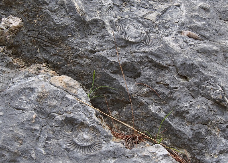
Fossil beach and Ammonite. (2750 m. route)
Leaving the Glass Balcony with the viaduct behind and the cannal bridge at the front you will have a longer route to take the curve that leads you to a bush coming out of the wall. A few metres before that just under the cable we go through is where the 'Ammonite' footprint is, a cephalopod from the Devonian era seas (400m.a) up to the end of the Cretaceous (65.5m.a). The fossil is protected by a methacrylate plaque confirms in this area known as the 'Fossil Beach' was submerged during those geological periods. Underneath and above the boardwalk there are other fossils, but you can spot the ones on the wall in front of you. A narrow path starts here and ends at the 'Falla Chica' and its apex 'V' favouring foldings that will make you change direction towards an opening protected from rockfalls by a vault and the 'Puentecito' of the old boardwalk.
This wall is in itself a great remain from the Jurassic Beach, where the waves of the sandy depths are still preserved, perfectly crystallised for hundreds of square metres and turning it into a huge fossil. The term ammonite comes from greek and their resemblance with ram's horns. Hence, in Egypt the god Amon was represented by a ram's head. These fossils settled on the sandy depths that became rocky vertical stratums during their hoisting.
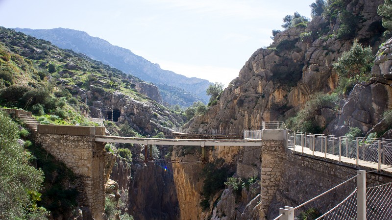
Hanging Bridge (2900 m. route)
Going up some wooden steps to get onto the already high metallic boardwalk, anchored 105m high, wall to wall and 35m long. This width and depth will give you a sensation of emptiness upon looking down, since the floor is a grid allowing visitors to appreciate the abyss and sometimes the fall of water 'water butterflies' as the ,locals call water drops that fall into the abyss hit by sunrays. If you are stable enough, you might also look up to spot vultures flying. For your safety it is important to say that before its inauguration in 2015, the bridge was tested to hold up to 50.000kg weights. Upon leaving it you will be able to spot the group of 'Jurassic Limestones' on entirely vertical stratum that fall over the waters and opening the Canyon.
Before reaching the Hanging Bridge, at the concrete area, you can also find commemorative plaques for different accidents that occurred at the Gaitanes' Gorge before its restoration in 2015. These plaques were hung in this spot by petition of their family members.
Exit Boardwalk and crossing over the bridge and railway tunnel(2950 a 3200 m. torno Sur)
The last part of El Caminito is done through stairs and a hanging boardwalk that also go above the old southern boardwalk. Looking up you can spot the Hydroelectric power station of El Chorro and to the right and up, the Pressure Surge Chamber of the Superior Tajo de la Encantada Dam that receives water through a pipe that saves the 400m slope.There, at the Mesas de Villaverde, the remains of the fortified city of Bobastro, important Mozarab site where the muladí leader Omar Ben Hafsún stopped the Emirs in Córdoba. The Boardwalk will take you to a curve with two rest benches before going up the stairs that go past to the bridge and railway tunnel and end at a gate that gives access to the exit path.
Did you know these vertical walls, the railway outline and other areas have been taken to the big screen by international well-known actors? One of these movies 'Von Ryan's Express was directed by Mark Robson in 1965, starring Frank Sinatra, Trevor Howard and a young Raffaella Carrá.
End Section. Exit Boardwalk
The Phenomenon of El Chorro. Exit path until El Chorro. (2.1 km downwards)
The Exit path (2.1km) has a small trail up with steps that then go down until a meeting point with an informative panel on the 'Geology' of the area and a pipe from the Aqueduct bridge to the Hydroelectric Power Station. From here going down surrounding the hill 'Majada de la Cebolleta' that has an iron Cross where those who go up the viewpoint sometimes leave stones. Continue down the slope until an old eucalyptus that has part of a pipe of the old Hydroelectric Power Station of El Chorro.
Here is where the path to the Cross and the Viewpoint starts, with excellent views of the entrance of the Gorge, the dam, Mesas de villaverde and the village of El Chorro. The term 'El Chorro' comes from the spectacular phenomenon produced by stron rains inside the province and the union of the three rivers 'junta de rios'. This strong and only riverbed entered the Canyons and left with a lot of pressure as a jet 'Chorro'.
End stretch. Caminito del Rey Avenue (Descend trail up to the El Chorro Station)
Los Albercones viaduct.
As you descend you will find to your right and hidden by a grove, a peculiar three-floor building with a stone front, rectancular bays and covered in green glazed tiles. It was built at the end of the 1920s as the residence of the Chief Engineer Rafael Benjumea, also used to lead the hydroelectric works on this side.
A bit further down at a closed curve you must look up to see the Albercones Viaduct, named Puente de la Josefona or De la Fuente. It is a magnificent road work from 1926 in stone and cement replacing the original metal one from 1865 'Puente Grande de Hierro'. The viaduct saves the thalweg between the Castillones through an arc over which other small ones aid the weight of the structure.
The House or 'Chalet del Ingeniero' as can be seen in old photographs was placed way above the old Station of El Chorro, with a privileged view over the dam, the pipes went down from the deposit and the village of El Chorro. Nowadays and after the Station was demolished it is at the level of the village.
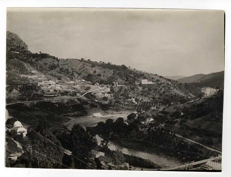
The old cillage of El Chorro.
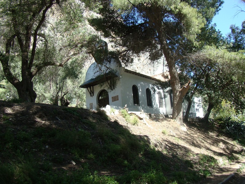
Going down almost at the level of the dam, you will reach a service path with trees and a sidewalk that goes by a Chapel-School also called 'Ermita de la Medalla de la Milagrosa'. Its 'butter stairs' named that after their wavy shape which resemble butter allow access first to the informative panels about the 'Wildlife' and 'Flora' and afterwards to the square where two long work benches in the shade are placed so you can read the commemorative plaques and watch the Virgin's mosaic. From the panels, an access ramp leads to an area above the Chapel with a palm grove viewpoint and benches pointing towards the Dam Tajo de la Encantada. The Chapel-School was built by Rafael Benjumea, as well as other buildings in the village nearby for the children of technicians and workmen and later on for the workers of the Station Salto del Chorro, achieving a great educational work. In this second level you can still see old building sites and some house-caves.
The construction of the Salto and the Hydroelectric Power Station brought a lot of activity to the village of El Chorro, increasing the number of inhabitants and buildings. Many of the buildings built by Rafael Benjumea had a combined aim, aesthetics and harmony alltogether, with garden areas. Other than the Chapel, the village was given a school with a library (Colegio de la Medalla Milagrosa) and even with tennis and basketball courts for fun. Workers were also exempt from paying electricity.
The helmet return cabin (end point of the route)
Glass Balcony (2690 m. route)
At this point you must have noticed the Gaitanes Gorge is the most spectacular section, not only due to its geological values but also because of the old infrastructure that was developed for the railway (tunnels, viaducts, service route...) but there is more. The Glass Balcony that stands on the rocky buttress and the boardwalk is a vertigo test for many visitors as the glass floor makes you feel like you are standing over the abyss as well as allowing you to see the vastness of the Cannon more closely. There is a poster advising not to be on the Balcony with more than four people even though tests have been done with way more weight than that.
From the viewpoint you will see the front of the railway and the service way as well as the tunnel and viaduct that replaced the old iron one. To drill into the tunnels they used so many dynamite cartridges that they became short in supply. Nevertheless and despite orographical difficulties, the section Málaga-Córdoba was built in just six years.
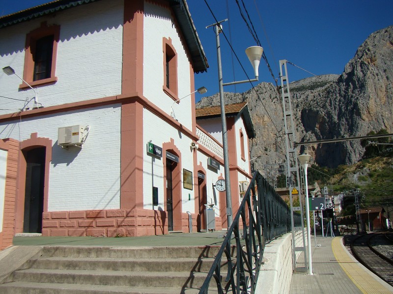
The railway station/halt of El Chorro and the Tunnels.
The station of El Chorro, along with the shuttle bus stop stands with a gable roof, the classic click and handrails to look down at the reils. The old water cans, signals and tunnel entries make a postcard stuck in time. With the railway construction Málaga-Cordoba, the small nucleus of El Chorro was favoured with a halt station, as it had been isolated before then. The railway link between both capitals (192km) concluded in 1865, with only 5 years and despite its orography (17 tunnels, 8 viaducts and 19 bridges). The route between El Chorro and Málaga was covered by two return trips, a morning and an evening one. From Álora to Málaga the trip was 59 minutes, it was not much because trains were legally required to not go past 30km an hour on winding sections and over 40km on flat sections.
Today the infrastructure for the High Speed Train (AVE) Córdoba-Málaga with a 155km route needed 19 viaducts (11km long) and 8 tunnels (25km long) all between Antequera and Málaga. The Abdalajís Tunnels, the longest ones in Andalucía (7.300m) that cross the Sierra del Valle de Abdalajís and Sierra de Huma in parallel were finished in 2006 in only one month and uising the tunneling machine 'La Alcazaba' which was 110m. The viaduct from Arroyo de las Piedras is the tallest one in the route (93.4m) and is one of the longest ones (1.208m)
To the right of the Station or halt of El Chorro-Caminito del Rey you can see the enormous rocky and extremelly vertical walls rise, such as the Pedrera de los Castillones. The area is widely known by mountain-climbers because of its difficulty and since 2014 it is one of the tests of the Spanish Climbing Championship that is celebrated here.
El "Caminito del Rey", ubicado en el Paraje Natural Desfiladero de los Gaitanes, se sitúa en el centro de la provincia de Málaga, a menos de 60 km de la capital, delimitado al norte por la Serranía de Ronda y los Llanos de Antequera y al sur por el valle del Guadalhorce y de la comarca histórica de Campo de Cámara.